Development, Branches, Approaches, Techniques in Geography
Geography, as a systematic study, traces its roots back to ancient Greece. The term “geography” was first coined by Eratosthenes, a Greek scholar who is often regarded as the “Father of Geography.” Eratosthenes not only named the discipline but also made significant contributions, such as calculating the Earth’s circumference and identifying the tilt of its axis.
Another influential figure was Ptolemy, who compiled extensive geographic knowledge in his work Geographike hyphegesis or “Guide to Geography” in the 2nd century A.D. His work summarized Greek and Roman geographical information and served as a foundation for future geographical studies.
During the 19th century, geography became more structured as an academic discipline. German geographers Alexander von Humboldt and Karl Ritter were instrumental in formalizing the study of geography. Humboldt introduced the systematic approach, which examines geographical phenomena globally and identifies patterns. Ritter, on the other hand, pioneered the regional approach, focusing on specific areas and studying all geographical aspects within that region.
Branches of Geography
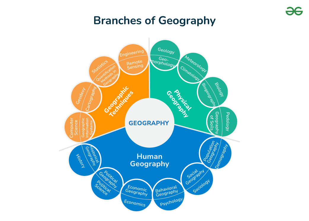
Geography is broadly divided into two main branches: physical geography and human geography. Each branch explores different aspects of the Earth and its inhabitants.
Physical Geography
Physical geography deals with the natural environment and its processes. Key areas within this branch include:
- Geomorphology: The study of landforms, their development, and the processes that shape them. Geomorphology is essential for understanding the Earth’s surface and its history.
- Climatology: The study of climate and weather patterns, examining how they vary over time and influence different regions.
- Biogeography: This field examines the distribution of living organisms across the Earth, bridging the gap between physical and human geography by studying how environmental factors and human activity impact ecosystems.
- Hydrology: The study of water bodies, including their distribution, movement, and impact on the environment.
Human Geography
Human geography explores the relationship between humans and their environment. It includes several subfields:
- Cultural Geography: The study of cultural practices, languages, and traditions, and how they vary across different regions.
- Development Geography: This branch focuses on the spatial patterns of development, studying the standard of living and quality of life in various regions.
- Political Geography: The study of political boundaries, territories, and the influence of political factors on geographical spaces.
- Urban Geography: The study of cities, their development, and the challenges they face, such as urbanization and infrastructure.
Approaches in Geography
Geographers use various approaches to study the Earth and its phenomena. These approaches help in analysing data and understanding spatial patterns.
Systematic Approach
The systematic approach, introduced by Alexander von Humboldt, studies geographical phenomena globally before identifying specific patterns or types. This method allows geographers to examine a topic comprehensively across different regions.
Regional Approach
Introduced by Karl Ritter, the regional approach divides the world into specific regions and studies all geographical phenomena within those areas. This method is particularly useful for understanding the unique characteristics of different regions.
Environmental Determinism and Possibilism
Environmental determinism is the theory that the physical environment, such as climate and landforms, determines human behavior and societal development. In contrast, possibilism argues that while the environment sets certain constraints, human innovation and culture ultimately shape society.
Techniques in Geography
Geographers use various techniques to collect, analyze, and present geographical data. These techniques are essential for understanding and visualizing spatial information.
Cartography
Cartography, the art and science of map-making, is one of the oldest techniques in geography. Modern cartography has advanced with digital tools, allowing for more precise and detailed maps.
Geographic Information Systems (GIS)
GIS is a powerful tool that combines spatial data with descriptive information, enabling geographers to analyze and visualize complex patterns and relationships. It is widely used in various fields, from urban planning to environmental monitoring.
Remote Sensing
Remote sensing involves gathering data about the Earth’s surface from satellites or aircraft. This technique is crucial for monitoring environmental changes, such as deforestation, urbanization, and climate change.
Fieldwork
Fieldwork is a traditional but vital technique in geography. It involves collecting primary data through observation, surveys, and interviews, providing firsthand insights into geographical phenomena.
Statistical Analysis
Statistical analysis helps geographers process and interpret numerical data, such as population surveys or climate data. This technique is essential for identifying trends and correlations in geographical studies.


