Andaman and Nicobar Geography Notes
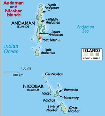
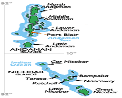
The Andaman and Nicobar Archipelago consists of over 345 islands, islets and rocky outcrops, with land area extending up to 8,249 km2 and a coastline stretch of 1,962 km; the Andaman Islands constitute 6408 km2 and the Nicobars 1841 km2.

The Andaman Islands are the extension of the submerged Arakan Yoma Tertiary Mountain range of Myanmar and the Nicobars are the continuation of the Mentawai Islands to the south and southeast of Sumatra. The main rocks of these islands are sandstone, limestone and shale. These two island groups situated in the Bay of Bengal span 6°45′ N to 13°41′ N (740 km) and 92°12′ E to 93°57′ E (190 km).
The nearest land mass to Great Nicobar Island is Sumatra, 145 km southeast; and the Myanmar coast is roughly 280 km north of Landfall Island, the northern- most island in the Great Andaman group.
The topography of the Andaman and Nicobar Islands is hilly and undulating, the elevation in the Andamans is from 0 to 732 m, Saddle Peak being the highest in North Andaman Island. In the Nicobars the elevation rises from 0 to 568 m, Mt Thuillier being the highest peak on Great Nicobar Island.
The Andaman Islands support one of the world’s most extensive mangrove ecosystems. Due to their long isolation, these islands have evolved significant diversity of flora and fauna with a high level of endemism.
The land area of 6408 km² in the Andamans constitutes 90% as reserves and protected areas of which 36% is tribal reserves. The entire Nicobar group is a tribal reserve and has four wildlife sanctuaries, two national parks and one biosphere reserve.
Important Observations about the Ecological Profile of Andaman and Nicobar Islands
- The ANI consists of very fragile island ecosystems and some of the most pristine in the world, which supports very unique flora and fauna. The landscape for large islands emerges from sea grass beds, coral reef or rocky outcrops, to beaches, littoral forest, Andaman slope forests, hilltops, into valleys and streams. Some of the dominant tree species in these luxuriant forests reach heights of 40- 60 m.
- In some areas in the Andamans along the west and the east coast, the landscape starts from reefs or rocky outcrops to steep rock faces with wind blown vegetation.
- The topography of all large islands in the Andamans, Little Andaman, Little Nicobar and Great Nicobar Islands, is mostly interlaced with perennial and seasonal freshwater streams and in some areas a matrix of mangrove creeks extending into marshes.
- Little Andaman Island has ecosystems that do not occur anywhere else in the Andamans or the Nicobars, mainly extensive fresh and saline water marshes and peat
- 9% Dense Forests, 1.7% Open Forests, 12% Mangroves. Mangroves cover an area of 929 km² and in the Nicobar the extent is 37 km² (Balakrishnan, 1989; Andrews & Sankaran, 2002).
- ANI are fringed by one of the most spectacular coral reefs in the world.
- The only primate, the Nicobar crab eating macaque (Macaca fascicularis umbrasa) occurs in the southern group of the Nicobar Islands. The islands are a birdwatcher’s paradise with as many as 250 species recorded.
- The complex geological history of these islands and the submergence of land bridges leading to isolation have left the islands with high levels of endemism. The widespread distribution of certain species indicates that there was an early evolution and dispersal throughout the archipelago. Endemism in reptiles and amphibians appears relative to species richness, islands with larger diversity have greater number of endemics.
- Protected areas in the islands are tribal reserves, national parks, wildlife sanctuaries, reserve, protected and preserved forest; and a biosphere reserve.
- An area of 513.70km² along the west coast of South Andaman Island is notified as a tribal reserve for the Jarawa people. This reserve extends north along the same coast into Middle Andaman Island, extending the reserve for another 338. 69 km². A 5 km distance into the sea from the high tide line right along the entire stretch of the Jarawa Reserve is also notified as part of the reserve.
- Strait Island, 6.01 km² in area, on the east coast of Middle Andaman Island supports a population of 45-50 of the last remaining Great Andamanese people.
- To the south west of South Andaman Island is North Sentinel Island with an area of 59. 67 km² and is inhabited by the Sentinalese people.
- The southern most island Little Andaman Island with a geographical area of 731. 57 km² and of this, 706. 49 km² with a distance of 3 km from the high tide line and into the sea along the coast has been notified as a tribal reserve for the Onge people.
- The entire group of 24 Nicobar Islands is notified as tribal areas; only 1,499.65 ha along the east coast from Campbell bay and up to 35 km is outside the Tribal Area and is inhabited by ex-servicemen, traders, government departments and the residents. Great Nicobar has a total area of 1044. 54 km² and of which 853. 19 km² is the tribal reserve, for both, the 380 Shompen people and the Nicobarese people.
- There are four national parks in the Andamans, Mahatma Gandhi Marine, Mount Harriet, Rani Jhansi Marine and Saddle Peak National Parks. The Nicobars have two areas notified as national parks and an area in Great Nicobar designated as the Great Nicobar Biosphere Reserve. Within the area of 960.40 km² in Great Nicobar Island, 110 km² is the Galathea National Park, situated on the south east of the island. On the east coast an area of 476. 73 km² is notified as the Campbell Bay National Park. An area of 885 km² includes the Nicobar Biosphere Reserve and all these parks are within the tribal area.
- The Barren Island in the Andamans has an active volcano. In the Bay of Bengal, there are two volcanic islands (Barren and Narcondam) situated within 80 km east of the Andaman Islands.
- Rice is the main crop in Andaman and Nicobar Islands. Coconut and Arecanut are the main cash crops of Nicobar.
Some other notes on Andaman and Nicobar Islands
Kalapani
Andaman & Nicobar were known as ‘Kalapani’ because of their having been a penal settlement under the British Rule. First establishment of East India Company was in 1789 which was abandoned in 1796. Following the first war of Indian Independence in 1857, the British India Government founded the penal settlement in these islands in 1858, primarily known as Kalapani, for the deportation of freedom fighters from the mainland India, which continued till the Second World War During the Second World War, the Japanese forces occupied the Andaman and Nicobar Islands in 1942. Further following the surrender of the Japanese forces in the Second World War, the British India Government reoccupied these islands in 1945 and continued their administration till the Independence of the country in 1947.
10 Degree Channel
It is a channel that separates the Andaman Islands from the Nicobar Islands in the Bay of Bengal. The channel is approximately 150 km wide, 400 fathoms deep running essentially along an east-west orientation. It is so named because it lies on the 10-degree line of latitude, north of the equator.

Landfall Islands
The northern most point is Landfall Island which is 901kms away from the mouth of Hoogly River and about 190kms from Burma.
Indira Point
The southern-most island is Great Nicobar, the southern-most tip of which Pygmalian Point now Indira Point is about 150kms away from Sumatra (Indonesia).
Saddle Peak
Saddle Peak in North Andaman at a height of 732 meters above sea level is the highest point in these islands.
Tribes
The original inhabitants of Andaman & Nicobar Islands lived in the forests on hunting and fishing. There are four Negrito tribes; viz., the Great Andamanese, Onge, Jarawa and Sentinalese in the Andaman group of islands and and the Nicobarese and Shompens in the Nicobar group.
Around 50 percent of the population is made up of settlers from the mainland India, some people call Andamans as a Little India or a mini-India. The settlers or ancestors of these settlers came either prior to 1947 or after 1947.
Chatam Island
The centre of activity of the Forest Department is Chatham Island. It has perhaps the biggest Saw Mill of its kind in Asia. Here logs are extracted with the help of elephants.
Mount Harriet
It is the highest hill around South Andaman and is about 365m . Formerly it was the headquarters of the Chief Commissioner.
Ross Islands
Seat of British Administration. The place came into decay with the shifting of the Chief Commissioner’s Office in 1942 as areas close to the shore had developed serious cracks and it was felt that the building was not safe. Ross Island was occupied by Japanese in March 1942. In October 1945 the Islands were re-occupied by the British. Today the Island is deserted.
Madhuban
A training ground for elephants.
Ritchie’s Archipelago
Ritchie’s Archipelago is a cluster of smaller islands which lie some 25–30 km (16–19 mi) east of Great Andaman. The archipelago comprises some 4 larger islands, 7 smaller islands and several islets. The 4 large islands are Havelock Island, Henry Lawrence Island, John Lawrence Island and Sir William Peel Island.
Havelock Island
Known for Coral Reefs
Neil Island
Known for timbering operations.
Chiriya Tapu
Also known as Bird Island
The Viper Island
There was a jail prior to commissioning of Cellular jail.
Car Nicobar
Most of the Nicobarese people are Christians.
Cellular Jail
Regarded by the freedom fighters all over the country as a place of pilgrimage and meant for “dangerous prisoners”. The construction of the Cellular Jail was taken up in 1898 and completed by about 1906. Whole jail consists of cells and each cell was meant for one inmate only. Cellular Jail originally had seven, three storied wings with a total of 698 cells, radiating from a central tower which had an additional storey to facilitate watch and ward.
“Tyranny of our Freedom Fighters”
Convicts who were sentenced to transportation for life were sent to these islands and interned in the Cellular Jail. Many political prisoners and revolutionaries were incarcerated here during the freedom struggle. Against the tyranny of the Jail management political prisoners were not allowed to communicate with their friends and relatives on the mainland except once in a year. Even the letters coming from mainland and newspapers subscribed by the prisoners were censored before being given to them. While fighting against this tyranny some political leaders had to lay down their lives. Many prisoners had gone insane in the Jail and ended their live by committing suicide rather than subjecting themselves to the indignities heaped on them.
Damage to Building:
In 1941 earthquake caused considerable damage to the Jail building. During the Japanese occupation from March 1942 to October 1954 further damage was caused to the building. All this finally resulted in the demolition of four out of the seven wings of the Jail. At present there are only three wings and these stand as silent monument to the great patriot’s and martyrs who were interned in this Jail, who had to sacrifice their lives at the altar of their country’s freedom.
